
Ali Nadir adlı kişinin rehberi
historical sightseeing places, Turkish Cuisine and World Cuisine Restaurant, bars, night clubs, bistros
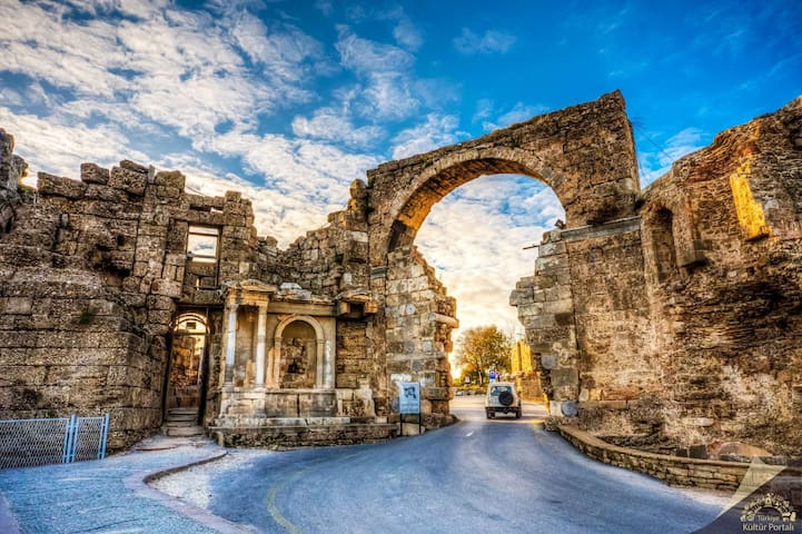
Antalya, which means Attalos Homeland, II. It was founded by Attalos. After the end of the Pergamon Kingdom (133 BC), the city remained independent for a while, and then fell into the hands of pirates. B.C. In 77, it was annexed to Roman territory by Commander Servilius Isauricus. B.C. In 67, it became the base of Pompey's navy. M.S. Hadrian's visit to Attaleia in 130 BC enabled the development of the city. Attaleia, whose name was seen as the episcopacy center during the Byzantine rule, showed a great development after it was captured by the Turks. Since the modern city was built on the ancient settlement, there are very few ancient ruins in Antalya. The first of the visible remains is a part of the harbor breakwater, which is described as the old port, and the city wall surrounding the port. Hadrian's Gate, which was restored in the part of the walls outside the park, is one of the most beautiful ancient monuments of Antalya.
Although it is known that there were temples, agora and theaters in all ancient cities in Attaleia, it is impossible to locate them today.
Kaleici; It is surrounded by inner and outer walls in the shape of a horseshoe, most of which have been destroyed and destroyed. The walls are the joint work of Hellenistic, Roman, Byzantine, Seljuk and Ottoman periods. The walls have 80 bastions. There are about 3000 houses with tiled roofs inside the walls. The characteristic structures of the houses not only give an idea about the architectural history of Antalya, but also reflect the lifestyle, traditions and customs of the region in the best way. Many stone blocks with ancient inscriptions were used in the construction of the walls, and they were well preserved until the 19th century. Today, only the remains of the walls such as Hıdırlık Tower, Hadriyan Gate and Clock Tower can be found in the city. The ancient city and walls covered by the sea are called Kaleiçi today. Streets and buildings are still filled with many signs reflecting the history of Antalya. The characteristic structures of the houses not only give an idea about the architectural history of Antalya, but also reflect the lifestyle, traditions and customs of the region in the best way.
88 คนท้องถิ่นแนะนำ
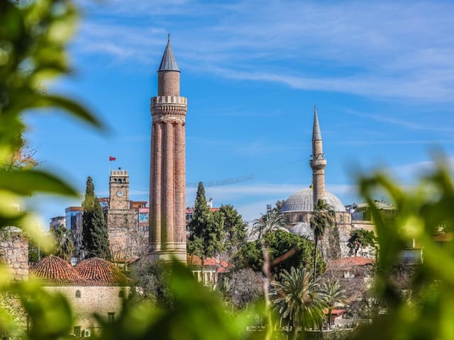
Kaleiçi
KaleiçiAntalya, which means Attalos Homeland, II. It was founded by Attalos. After the end of the Pergamon Kingdom (133 BC), the city remained independent for a while, and then fell into the hands of pirates. B.C. In 77, it was annexed to Roman territory by Commander Servilius Isauricus. B.C. In 67, it became the base of Pompey's navy. M.S. Hadrian's visit to Attaleia in 130 BC enabled the development of the city. Attaleia, whose name was seen as the episcopacy center during the Byzantine rule, showed a great development after it was captured by the Turks. Since the modern city was built on the ancient settlement, there are very few ancient ruins in Antalya. The first of the visible remains is a part of the harbor breakwater, which is described as the old port, and the city wall surrounding the port. Hadrian's Gate, which was restored in the part of the walls outside the park, is one of the most beautiful ancient monuments of Antalya.
Although it is known that there were temples, agora and theaters in all ancient cities in Attaleia, it is impossible to locate them today.
Kaleici; It is surrounded by inner and outer walls in the shape of a horseshoe, most of which have been destroyed and destroyed. The walls are the joint work of Hellenistic, Roman, Byzantine, Seljuk and Ottoman periods. The walls have 80 bastions. There are about 3000 houses with tiled roofs inside the walls. The characteristic structures of the houses not only give an idea about the architectural history of Antalya, but also reflect the lifestyle, traditions and customs of the region in the best way. Many stone blocks with ancient inscriptions were used in the construction of the walls, and they were well preserved until the 19th century. Today, only the remains of the walls such as Hıdırlık Tower, Hadriyan Gate and Clock Tower can be found in the city. The ancient city and walls covered by the sea are called Kaleiçi today. Streets and buildings are still filled with many signs reflecting the history of Antalya. The characteristic structures of the houses not only give an idea about the architectural history of Antalya, but also reflect the lifestyle, traditions and customs of the region in the best way.
Side, the most important port city of Pamphylia in ancient times, was established on a peninsula with a width of 350-400 meters, located 80 kilometers east of Antalya and 7 kilometers southwest of Manavgat.Side VII. century, it became a settlement center. VI. BC. century, it came under the rule of the Lydian Kingdom with all Pamphylia, and after the collapse of the Lydian Kingdom in 547/46, it came under the rule of the Persians. The city, which preserved its freedom to some extent in this period, minted coins in its own name. Side, which opened its doors to the Macedonian king without showing any resistance during the Anatolian campaign of Alexander the Great (334 BC), later became one of the great coinage centers established by Alexander. Side, which constantly changed hands between the Hellenistic Period kingdoms after the death of Alexander, was built in BC III. century, first by the Ptolemies, and in the years 215-189 BC, it was under the rule of the Seleucids. According to the Peace of Apameia made in 188 BC, when the Seleucids were defeated in the war they opened against the Romans, Pamphylia and in the meantime Side were given to the Kingdom of Pergamon. On the other hand, Side regained its independence after a while and experienced one of the brightest periods in history.The fact that Antiochus VII, who ascended the throne of Syria in 138 BC and later took the nickname "Sidetes", was sent to Side to study in his youth is an indication of how important the city is in the Eastern Mediterranean. This bright period of the city did not last long. Piracy, which started in Pisidia and mountainous Cilicia regions in the 1st century BC, also jumped to Pamphylia and therefore Side, and the Sidelis, who could not cope with the pirates, had to open their ports and markets to them. Finally, in 78 BC, after the Roman Consul Publius Servilius cleared the region from pirates, Side was also attached to the Roman Empire, like other cities of Pamphylia.On the ruins of Side Antique City, which is known as a trade and port city, XX. Selimiye Village was founded by Cretan immigrants at the beginning of the century. Built on a peninsula, Side, as in other Pamphylia cities, stretches along a monumental street that starts from the main gate of the city. The main street, which starts from the “Great Gate” in the northeast, continues along the peninsula in an almost straight line, except for the curve in front of the Theater, and ends with a large square near the temples. The second largest street of the city extends from the “Great Gate” to the south of the city. Both streets have colonnades and there are columned porticos with Corinthian caps on both sides and a row of shops behind them.
64 คนท้องถิ่นแนะนำ
เมืองโบราณไซด์
Çağla SokakSide, the most important port city of Pamphylia in ancient times, was established on a peninsula with a width of 350-400 meters, located 80 kilometers east of Antalya and 7 kilometers southwest of Manavgat.Side VII. century, it became a settlement center. VI. BC. century, it came under the rule of the Lydian Kingdom with all Pamphylia, and after the collapse of the Lydian Kingdom in 547/46, it came under the rule of the Persians. The city, which preserved its freedom to some extent in this period, minted coins in its own name. Side, which opened its doors to the Macedonian king without showing any resistance during the Anatolian campaign of Alexander the Great (334 BC), later became one of the great coinage centers established by Alexander. Side, which constantly changed hands between the Hellenistic Period kingdoms after the death of Alexander, was built in BC III. century, first by the Ptolemies, and in the years 215-189 BC, it was under the rule of the Seleucids. According to the Peace of Apameia made in 188 BC, when the Seleucids were defeated in the war they opened against the Romans, Pamphylia and in the meantime Side were given to the Kingdom of Pergamon. On the other hand, Side regained its independence after a while and experienced one of the brightest periods in history.The fact that Antiochus VII, who ascended the throne of Syria in 138 BC and later took the nickname "Sidetes", was sent to Side to study in his youth is an indication of how important the city is in the Eastern Mediterranean. This bright period of the city did not last long. Piracy, which started in Pisidia and mountainous Cilicia regions in the 1st century BC, also jumped to Pamphylia and therefore Side, and the Sidelis, who could not cope with the pirates, had to open their ports and markets to them. Finally, in 78 BC, after the Roman Consul Publius Servilius cleared the region from pirates, Side was also attached to the Roman Empire, like other cities of Pamphylia.On the ruins of Side Antique City, which is known as a trade and port city, XX. Selimiye Village was founded by Cretan immigrants at the beginning of the century. Built on a peninsula, Side, as in other Pamphylia cities, stretches along a monumental street that starts from the main gate of the city. The main street, which starts from the “Great Gate” in the northeast, continues along the peninsula in an almost straight line, except for the curve in front of the Theater, and ends with a large square near the temples. The second largest street of the city extends from the “Great Gate” to the south of the city. Both streets have colonnades and there are columned porticos with Corinthian caps on both sides and a row of shops behind them.
Alanya is a tourism district of Antalya province in Turkey's Mediterranean Region. Its distance from the city center is 154 kilometers.Alanya is a historical city of rare beauty that hosted pirates in ancient times, feudal lords during the Byzantine period and finally rose to the capital during the Anatolian Seljuk period.
Alanya was located between Pamphylia and Cilicia in ancient times. According to Herodotus, the people of this region are descendants of the people who dispersed to Anatolia after the Trojan War.
Researches (Kadıini Cave-1957) revealed that the first settlement dates back to the Upper Palaeotic Period, 20 thousand years ago.
Its first known name in history is Coracesium. It was under the invasion of the Persians in the 4th century BC. It later became a haven for pirates. In 139 BC, the Seleucid Empire invaded the city. But even after that, the city could not get rid of being a shelter for pirates. The city, which was added to the territory of the Roman Empire by the Roman commander Magnus Pompeius in 65 BC, became Kalonoros, meaning "beautiful mountain" in the Byzantine period with the collapse of Rome.After the Crusader armies established the Latin Empire in Istanbul in 1204, a vacuum of authority arose in Anatolia. Kyr Vart, a feudal lord, established dominance in Kalonoros on behalf of the Armenian Kingdom of Cilicia.
112 คนท้องถิ่นแนะนำ
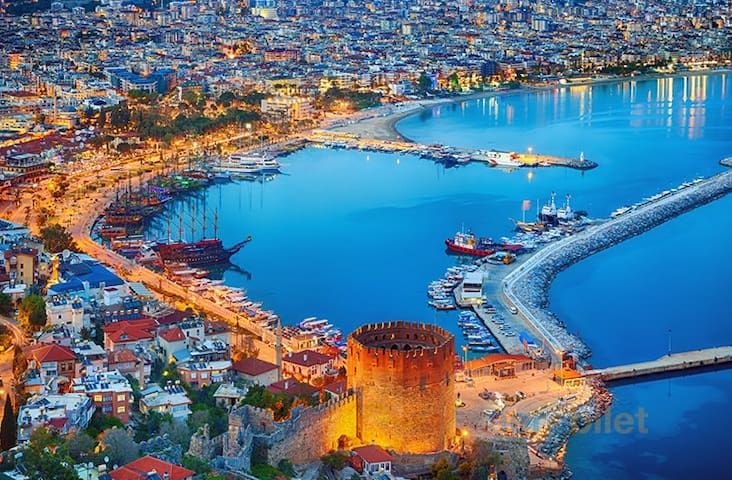
Alanya
Alanya is a tourism district of Antalya province in Turkey's Mediterranean Region. Its distance from the city center is 154 kilometers.Alanya is a historical city of rare beauty that hosted pirates in ancient times, feudal lords during the Byzantine period and finally rose to the capital during the Anatolian Seljuk period.
Alanya was located between Pamphylia and Cilicia in ancient times. According to Herodotus, the people of this region are descendants of the people who dispersed to Anatolia after the Trojan War.
Researches (Kadıini Cave-1957) revealed that the first settlement dates back to the Upper Palaeotic Period, 20 thousand years ago.
Its first known name in history is Coracesium. It was under the invasion of the Persians in the 4th century BC. It later became a haven for pirates. In 139 BC, the Seleucid Empire invaded the city. But even after that, the city could not get rid of being a shelter for pirates. The city, which was added to the territory of the Roman Empire by the Roman commander Magnus Pompeius in 65 BC, became Kalonoros, meaning "beautiful mountain" in the Byzantine period with the collapse of Rome.After the Crusader armies established the Latin Empire in Istanbul in 1204, a vacuum of authority arose in Anatolia. Kyr Vart, a feudal lord, established dominance in Kalonoros on behalf of the Armenian Kingdom of Cilicia.
Pamukkale is a natural location in the province of Denizli in southwestern Turkey. It includes the terraces and travertines of the carbonate minerals remaining from the Kent Thermal Springs and the flowing waters.
The ancient city of Hierapolis was built on a white "castle" with a total length of 2,700 meters, a width of 600 meters and a height of 160 meters. Pamukkale can be seen from the hills on the opposite side of the valley in the center of Denizli, 20 km away. The ancient city of Laodicea is located 5-10 km away. There is Karahayıt village, which is an international thermal center, 5 km ahead. Pamukkale is included in the World Heritage List determined by UNESCO. travertines; In addition to visual richness, it is good for heart ailments, rheumatism, digestion, respiration, circulation and skin disorders.
Pamukkale terraces consist of travertine, a sedimentary rock precipitated by the hot spring water.
In this region, there are 17 hot water springs in the temperature range from 35 °C to 100 °C.
The distance between Antalya and Pamukkale is about 300 km.
69 คนท้องถิ่นแนะนำ

ปามุกกาเล
Pamukkale is a natural location in the province of Denizli in southwestern Turkey. It includes the terraces and travertines of the carbonate minerals remaining from the Kent Thermal Springs and the flowing waters.
The ancient city of Hierapolis was built on a white "castle" with a total length of 2,700 meters, a width of 600 meters and a height of 160 meters. Pamukkale can be seen from the hills on the opposite side of the valley in the center of Denizli, 20 km away. The ancient city of Laodicea is located 5-10 km away. There is Karahayıt village, which is an international thermal center, 5 km ahead. Pamukkale is included in the World Heritage List determined by UNESCO. travertines; In addition to visual richness, it is good for heart ailments, rheumatism, digestion, respiration, circulation and skin disorders.
Pamukkale terraces consist of travertine, a sedimentary rock precipitated by the hot spring water.
In this region, there are 17 hot water springs in the temperature range from 35 °C to 100 °C.
The distance between Antalya and Pamukkale is about 300 km.